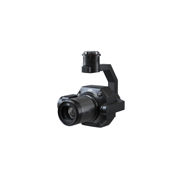
DJI Zenmuse P1
DJI Zenmuse P1 | Full-Frame Aerial Photogrammetry Payload
The DJI Zenmuse P1 integrates a full-frame sensor with interchangeable fixed-focus lenses on a 3-axis stabilized gimbal. Designed for photogrammetry flight missions, the DJI Zenmuse P1 takes efficiency and accuracy to a whole new level — setting a new benchmark for aerial surveying and geospatial data collection.
DJI Zenmuse P1 Key Features
Extraordinary Efficiency
The P1 includes a full-frame, low-noise, high-sensitivity sensor that captures a photo every 0.7 seconds during flight and can cover 3 km² in a single mission — maximizing operational throughput for large-scale survey projects.
Remarkable Accuracy
Equipped with a global mechanical shutter and the TimeSync 2.0 system — which synchronizes time across all modules at the microsecond level — the Zenmuse P1 captures centimeter-accurate data combined with real-time position and orientation compensation technology.
Full-Frame Camera Specifications
- 45MP full-frame sensor with 4.4μm pixel size
- Low-noise, high-sensitivity imaging for extended daily operational time
- Photo every 0.7 seconds during flight
- TimeSync 2.0 aligns camera, flight controller, RTK module, and gimbal at microsecond level
Multiple Fixed-Focus Lens Options
- Global mechanical shutter — 1/2000 second shutter speed
- Sends median exposure pulse in microseconds
- Supports 24mm, 35mm, and 50mm lenses with DJI DL mounts
Robust Versatility
Create 2D, 3D, and detailed models using the integrated 3-axis gimbal outfitted with 24/35/50mm lenses and the Smart Oblique Capture feature.
Smart Oblique Capture
Cover 7.5 km² in a single workday. Smart Oblique Capture automatically rotates the gimbal to take photos at different angles needed for oblique photogrammetry — capturing only essential photos at the edge of the flight area, increasing post-processing efficiency by 20–50%.
Smart Data Management
- Mission result files automatically associated with Mission Name and Mission Time
- Centralized storage for photos, GNSS data, timestamps, and MRK files
- Image metadata contains camera intrinsic/extrinsic parameters and RTK status
- Fieldwork Report for immediate post-flight data quality verification — position data, image count, RTK status, and positioning accuracy
Mission Modes
- 2D Orthomosaic Mission
- 3D Oblique Mission
- Detailed Modeling Mission
- Real-Time Mapping Mission
Compatible Aircraft
- DJI Matrice 300 RTK
- DJI Matrice 350 RTK
Applications
- Topographic Mapping: 1:500 scale accuracy without ground control points
- Cadastral Surveying: Centimeter-level accurate 3D reality models
- AEC and Surveying: Full project lifecycle management with 2D and 3D drone data
- Natural Resource Management: Measure, classify, or determine ownership of water bodies and forests
- Geological Investigation: Millimeter-level accurate aerial data of geological hazard sites
- Disaster Site Modelling: Real-time overviews of large disaster-affected areas for critical decision support
Payment & Security
Payment methods
Your payment information is processed securely. We do not store credit card details nor have access to your credit card information.